


taradeau les arcs retour

clintest
User
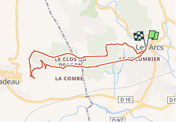

Length
9.4 km

Max alt
247 m

Uphill gradient
229 m
Km-Effort
12.4 km

Min alt
87 m

Downhill gradient
228 m
Boucle
Yes
Creation date :
2022-10-17 10:58:23.555
Updated on :
2022-10-17 13:23:31.325
2h24
Difficulty : Difficult

FREE GPS app for hiking
 SityTrail
IGN / Geographical institutes
SityTrail Plus
The world is yours!
About
Trail Walking of 9.4 km to be discovered at Provence-Alpes-Côte d'Azur, Var, Les Arcs-sur-Argens. This trail is proposed by clintest.
Positioning
Country:
France
Region :
Provence-Alpes-Côte d'Azur
Department/Province :
Var
Municipality :
Les Arcs-sur-Argens
Location:
Unknown
Start:(Dec)
Start:(UTM)
295945 ; 4815336 (32T) N.
Comments